


 1 comment
The Island’s geology had always seemed a static, case-closed subject to me. Then it happened that I was reading Robert Oldale’s book, Cape Cod, Martha’s Vineyard and Nantucket: The Geologic Story, at my off-Island home in Mississippi when Hurricane Katrina roared through. A tree dropped on our roof and shook the ground we stood on. Yet it was nothing compared to places farther south on the Gulf Coast. I’d been planning to photograph the Island’s new ferry under construction at V.T. Halter Marine in Pascagoula. Now the boat intended to take people back and forth across the water on the northern coastline was temporarily underwater on the south coastline. The submerged hull of the Island Home seemed a symbolic connection to the calamity that awaits all coastal communities. The last chapter of Oldale’s book struck with sudden relevance and force: “The future of the Cape and Islands holds both good news and bad news. The bad news is that the Cape and Islands are slowly being eroded away by the waves,” he wrote. “The good news is that sooner or later every piece of property on the Cape and Islands will be on the waterfront.”
When Oldale wrote that in the 2001 edition of The Geologic Story (On Cape Publications, 2001 [revised], 208 pages, $14.95, soft cover), he didn’t, of course, mean to take people’s losses lightly. He meant that the earth is continuing to do what it’s been doing for eons. All the castles we build on the sand can’t stop that. The best we can do is understand where the land comes from to get an indication of where it’s going. “Everything you see on the Island has been affected by, or was a consequence of, the Island’s geological history,” naturalist Suzan Bellincampi, director of training and program development for The Trustees of Reservations, told me when I called her to get my bearings. “On Martha’s Vineyard, geology is destiny.”
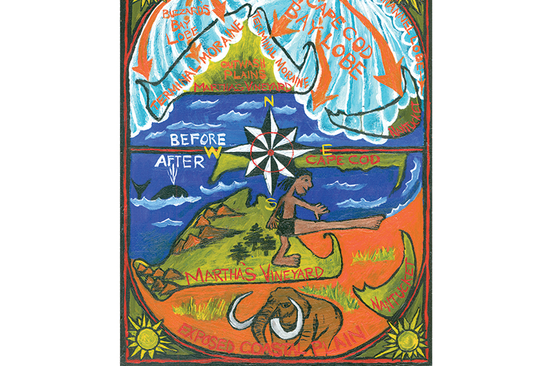
A brief debriefing on destiny Though the bedrock far beneath the Vineyard dates back hundreds of millions of years, the actual formation of the Island itself happened more recently. About 23,000 years ago, during the Wisconsin stage (the last of the glacial periods, at least for now), an ice sheet that had formed in the Laurentian mountains of northern Canada pressed south through New England. In New Hampshire the ice, more than a mile deep, buried the White Mountains.
By the time it reached the Cape, it was a little less substantial – but still at least 1,500 feet thick. The force of the ice mass pried boulders and rocks lose from the mainland and propelled them in its path. It nosed forward with a scalloped front. The Buzzards Bay Lobe shaped the western end of the Island from West Chop along the north shore to Aquinnah. The Cape Cod Bay Lobe formed the eastern end from Chappaquiddick to Oak Bluffs. At its farthest reach, the Laurentide ice sheet laid down its load of rocks and boulders at the Gay Head Cliffs, Cedar Tree Neck, and Menemsha Hills, creating the Island’s backbone – what geologists call terminal moraines. Though the glacier stopped there, the tremendous rush of meltwater carried finer gravels, sands, and silt beyond the moraines into the outwash plains that make up the center and southern regions of the Island (Katama, Wasque Reservation, Long Point Wildlife Refuge). The torrents of meltwater dug channels southward (now called frost bottoms), creating ponds and stream beds that rushed to the sea.
Within a few thousand years the Island’s groundwork had been laid. To geologists, whose job it is to take the long view, the glacier’s work was remarkably quick. To the rest of us, such a magnitude of time and ice is hard to imagine. I phoned Oldale, geologist emeritus of the US Geological Survey in Woods Hole, and asked him what it would have been like to be here when the glacier arrived.
On the brink of the berg
“It would have been something to see,” he told me. “If you were standing in front of the glacier looking to the north, it would look like a wall of ice with a gentle slope. On top of the glacier is essentially snow. The depth increases compaction, pressing the snow into ice – essentially like squeezing a snowball. Where the glacier’s clean, it appears turquoise blue in color, though in the mid-part it may have bands of dirt that were at the surface at one point. The meltwater is vast – volumes we can’t even imagine – and carries sediment. It doesn’t just melt from the top down, but at the base, as well, from the heat of the earth and the pressure. During catastrophic breaks, when the glacier was calving off, there would be a loud noise, then not so loud, like when a tree falls in the forest.”
Probably the closest we can come to experiencing such an event is to take an expedition into arctic Alaska. Suzan Bellincampi was on such a trip when she heard a glacier creaking and cracking. “It was amazing timing that we were there when it happened,” she said. “We were, like, ‘Whoa!’ It seemed to happen in slow motion. You think when something that big breaks, it will make a giant wave that will swamp your boat, but it doesn’t. The air is cold and weird. It gives you goose bumps.”
She adds, however, that the drama of a calving iceberg in Alaska is not exactly equal to the ponderous progress of the Laurentide ice sheet in New England. “A lot of people compare the glacier to a bulldozer,” says Bellincampi, “but it was so slow – more like molasses.”
After the chill is gone
By about 18,000 years ago, the global climate had warmed enough to force the ice sheet’s retreat north. The worldwide sea level then was about 300 feet lower than it is now, meaning that the shoreline south of the Island was exposed 75 miles farther out than today, and that the Islands, in fact, were still connected to the mainland. Bears, wolves, moose, caribou, bison, musk oxen, and other creatures roamed the tundra grasses, evergreen forests, and marshes that made up the emergent continental shelf. Fossils tell us that.
In over four decades as a geologist, Oldale has examined his share of elephant teeth. “It was not unusual for fishermen to come into our Woods Hole office with a mammoth or mastodon tooth they’d dredged up in their nets, wondering what it was,” says Oldale. “A lot were found to date from 11,000 to 12,000 years ago. About that time, the native population entered the New England area and probably hunted mastodon and mammoth as well as smaller game, fish, and birds on the exposed coastal plain.”
The Island sets sail
The Wampanoags take pride in having been present and having survived such formative times. Their creation stories are rooted in the geologic changes around them. “Our people walked from the mainland prior to the separation,” says Tobias Vanderhoop, education program coordinator for the Wampanoag Tribe of Gay Head (Aquinnah). “We’ve been here since before the Island was an island.”
About 7,500 years ago, seawater flooded Vineyard Sound’s deepest areas. The Wampanoag’s oral tradition describes what happened: “The giant Moshup dragged his toe between the Island and the mainland,” says Vanderhoop. “It filled with water, and that’s how the land became separated.”
His ancestors would have seen the sea level rising fast enough over the gently sloping coastal plain to make a notable difference within a lifetime. Fifteen hundred years after the sea split the Vineyard from the Cape, the water submerged Nantucket Sound, separating the Islands from each other, as well. For the next 4,000 years, sea level kept rising, until the Vineyard shoreline was within several miles of where it is now. By 2,000 years ago, the Island had many of the features it has today (minus the tourists and traffic jams). It had major barrier spits, outer islands, lagoons, bays, salt marshes, and the most pronounced formation carved by the glacier, the Gay Head Cliffs of Aquinnah.
“The famous colored cliffs at Gay Head are perhaps the most striking and well-known natural feature of the Vineyard and may be the largest display of Pleistocene [ice age] sediments to be found anywhere in the world,” wrote Anne Hale in Moraine to Marsh: A Field Guide to Martha’s Vineyard (Watership Gardens, 1988).
In the many layers and colors of the Cliffs – red, tan, black, green, yellow, white – we find some of the oldest and youngest exposed landscape in the Northeast. Oldale remembers seeing the Cliffs for the first time in 1957 and finding them particularly fascinating. “The strata is much older than the glacial strata in most of New England,” he says. “The sediments exposed tell the story back as far as the age of the dinosaurs, the Cretaceous Period, 100 million years ago.”
That story, however, is not told directly from top to bottom on the face of the Cliffs, since the ice shoved older layers on top of newer ones. The Cliffs have been described as everything from a shuffled deck of cards to a layer cake scrambled with an eggbeater. When Suzan Bellincampi explains the formation of the Cliffs to groups of kids (and curious adults), she likes to take five or six layers of different colored clays, flatten them into sheets, then pile them one on top of the other. She squishes them together in the way the ice sheet would have bulldozed them into a heap, then cuts the clay in half, exposing the layers as we see them in the Cliffs. “I like the visual,” she says. “It looks like ribbon candy with the edges licked off.”
That’s my kind of geology. There’s more to these rocks than I’d suspected. Oldale, who has walked with his head down studying the ground since he was a boy, can spot fossils in the Gay Head Cliffs at a glance – a shark’s tooth or bone shard from a seal or whale. “You develop an eye for it,” he said. “Most people would walk right by and not see it, but as a geologist I can pick it right out. The Cliffs contain fossils in some instances that don’t exist anywhere else.”
Wampanoag elders have also been able to spot the fossils layered into the multi-colored cliffs. “My ancestors weren’t necessarily scientists,” says Tobias
Vanderhoop. “They did not take the instruments we have today and analyze the Cliffs, but their stories offer an understanding of why things are as they are.” According to the tribal creation stories, Moshup, the giant whaler, lived with his family on the sacred Cliffs, where he watched over and cared for the Wampanoags. “He would go out into the water and pick up whales to feed his people and his family,” says Vanderhoop. “He would take them back and beat them against the Cliffs. The whales’ blood stained the cliffs and changed the clay color. On a molecular level the elements in clay are comparable to those found in blood, so lines can be drawn between the oral traditions and the science.”
A chip off the old ice block
Though the Cliffs may be the most dramatic example of the Island’s geological history, they are far from the only one. “People don’t realize that every day we’re living and breathing geology,” says Suzan Bellincampi. “By knowing a little bit about it, you can look at the plants and animals around you, and they’ll tell you a story.”
For instance, the reason that there are so many more stone walls up-Island than down-Island, she says, is that the glacier stopped there, dropping the heaviest boulders, called glacial erratics. The land on the hilly moraines is dense with clay, so it holds more water, creating vernal ponds, and nurturing such plants as red maple, beetlebung, and ferns. In contrast, the soil left by the glacier meltwater in the outwash plains is of a harsh, sandy nature. The land is flat and drains water, rather than holding it, so instead of seeing maple and beetlebung, you see grasses and scrub oak. “Once you know the Island’s geology,” says Bellincampi, “it all makes sense.”
The glacier is gone, but the changes go on
The geological history is worth paying attention to not only for what it tells us about the past and the present landscape, but also about the future. As James O’Connell, coastal processes specialist of the Woods Hole Sea Grant and Cape Cod Cooperative Extension, told me, “The first of the land forms laid down by the glaciers will be the last to go.”
What he means is that the Island’s higher, clay-dense, rock-strewn terminal moraines in the north and northwest regions of the Island will survive long after the porous, low-lying pebbles and sand of the south side have been swept away by the wide-open ocean waves. Places such as southern Chilmark, West Tisbury, and Edgartown are subject to erosion rates that are greater by a factor of five than the north and northwest regions of the Island. The coastal land from Edgartown to southeast West Tisbury has the highest long-term erosion rate on the Island – from four to six feet per year. “If you take the five feet per year average,” O’Connell says, “that means within 60 years everything within 300 feet of the shoreline will be gone.”
Despite the recent shock of Katrina, I still find that speed of geological change inconceivable. But it gets even worse, for as Oldale says, average rates of erosion can be somewhat misleading. “For about thirty years at Wasque Point, at the southeast corner of Martha’s Vineyard, the average erosion rate was about thirty-three feet per year,” he wrote in The Geologic Story. “During most of that period, the point was protected by a wide foreshore; but one year when the foreshore was absent and the point was exposed to direct wave attack, it retreated some 350 feet.” That’s a big jump in a year.
Geologists by nature and training seem to take the earth’s shifts in stride. The layman, however, often wants to know what can be done to hold back the processes. Unfortunately, efforts to strengthen bluffs with riprap or revetments only accelerate the erosion to neighboring beaches. “Once you have a long series of walls, you have no beach at high tide,” says O’Connell. “Unfortunately, that’s the situation in over-developed parts of the Cape. The beach is a system that renews itself with waves and currents transporting sand along the shore. If you interrupt that process you intensify the problem. It’s a Catch-22.”
On the Vineyard, he says, the armory of riprap and jetties at Oak Bluffs is needed to keep the harbor open for the ferries and boats. But it’s because of that man-made interference that Beach Road, farther down the shoreline, is washed over so often. Sand is trucked in to build up Joseph A. Sylvia State Beach temporarily after powerful storms, but it’s a short-term solution to long-term geology. “We try to balance it as best we can,” says O’Connell. But after twenty years as a coastal specialist, he knows the only course of action is reaction, and over the long term, that won’t be good enough.
Sudden changes alert us to the steady geologic changes, evolving all along at the less appreciable rates of thousands and tens of thousands of years.

Geology leaps out of the textbook and into your pathway. “You can look at lichen and know it is a pioneer species with an acidic reaction that will eventually break rocks down to sand,” says Suzan Bellincampi. “But it’s not going to happen in my lifetime, or my kids’ lifetime, or their kids’ lifetime. You have to learn to look at the landscape for it to tell you what’s happening over geologic time. That’s what’s cool."

Comments (1)